1822 plan of Stonebridge Pond
From Part 2 you’ll remember that there was a port (Cilling) somewhere in the Faversham area in 699; that Faversham itself was a town, and a Royal one at that, by 811; that it may have been a founder-member of the Confederation of Cinque Ports in the 10th century; and that without its port it would never have emerged as a town.
How far upstream was the Creek navigable in the early middle ages, soon after the Norman Conquest in 1066? This is the next question to which an answer is needed if we’re to understand how it influenced the town’s development. Unfortunately it’s a vexed one.
Nowadays there are two sluices to control water levels. One is under the Creek Bridge, the other at the head of the Creek. The purpose of the one under the Creek Bridge is twofold. First, at high tide it enables water to be retained in the Basin above it so that this can be released at low tide to clear silt from the Creek bed. Second, at high tide when the Bridge is swung open, it enables sea-going vessels to reach the Basin and berth there.
In fact this sluice has not been operated for many years and as a result mud and silt have built up in the main reaches of the Creek below it. Thanks to efforts by the Creek Consortium, the sluice gates have recently been repaired by the navigation owners, Medway Ports. This business is owned by Peel Holdings, whose HQ is in Manchester. Among its many other interests are the Manchester Ship Canal, the Trafford Centre in Manchester, the Ports of Liverpool and Sheerness, Liverpool John Lennon Airport and three other provincial airports.
The Creek Bridge, in case you ask, cannot be swung at present, because for some years it has needed major repairs. The Creek Consortium is trying to get these undertaken.
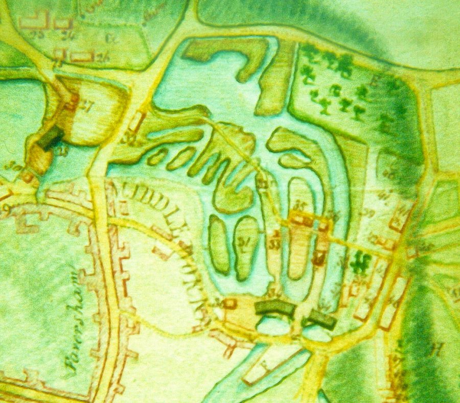
The second sluice, at the head of the Creek, cannot be seen, as it is at the north end of Stonebridge Pond, whose water level it is used to regulate. It is the present-day counterpart of the first sluice installed in 1558. The purpose of this, like the one under the Creek Bridge, was to build up a head of water at high tide so that the this could be be used to flush the Creek of silt. Illustrated is an 1822 plan of Stonebridge Pond, when it formed part of the Home Gunpowder Works. The road running ‘south-north’ on the left is West Street.
It took the place of a tide mill (Flood Mill) and the funds for it came from the bequest of Henry Hatch. Two years before his death in 1533 he’d said “I mean to bestow such cost upon the Haven and Creek that a ship with two tops [masts] may come up to the Crane [meaning probably Standard Quay]”. He was a successful merchant and businessman from Sundridge, near Westerham, and, as he had no children, had decided that as he’d made his fortune in the town he’d leave it most of the money and property he’d amassed.
His point was that in his day the Creek was so badly silted that big vessels could only get up as far as Thorn Quay, below the present sewage works. For the rest of their mile-long journey to or from the town, cargoes had to be moved, inconveniently, in carts or shallow-draught lighters.
The existence of a tide mill at the head of the Creek means that originally Stonebridge Pond and perhaps the lowest reaches of the Westbrook, which feeds it, were tidal and so perhaps, before it was built, navigable by small shallow-draught vessels. Contours suggest that, if it was, such vessels may have been able to reach the lower end of Tanners Street, near which the town’s first Guildhall was standing in the early 16th century. But this is speculation and more research is needed.
