Faversham Creek prospered for over 250 years after a sluice to clear it of mud and silt was installed in 1558. However…
In the shape of the Whitstable & Canterbury Railway a challenge arrived in 1830. For at least 150 years, since Fordwich on the Stour had ceased to be accessible to trading vessels, Faversham had taken its place as the port for Canterbury and its hinterland. The new railway was connected to a brand-new harbour at Whitstable in 1832, and immediately the fortunes of the Creek and the town were in jeopardy.
The threat had been foreseen, it’s true. The Act authorising the Railway had been passed in 1825 and a year earlier the great engineer Thomas Telford had been commissioned to suggest improvements to the Creek. Its disadvantage was that its course from The Swale to the town was circuitous, making it difficult and slow to negotiate. This had not mattered when there was no competition, but now that there would be, it did.
To overcome this Telford suggested a new straight cut from Holly Shore, past Ham Farm, to Standard Quay – a short ship canal in fact. This was a suitably bold solution, but the necessary funds could not be raised from the business owners who might have benefitted from it. £32,000 (equivalent to £1.35m today) was needed, but not much more than half that put up.
So after Whitstable Harbour opened in 1832 trade began ebbing away. Improbably, but happily, the situation was transformed by the Municipal Reform Act three years later. Hitherto the town’s charities had been administered by the Borough Council but now an independent body was set up to manage them. Through the Hatch bequest, which had provided for the installation of the 1558 sluice, the new Municipal Charity Trustees had a stake in the Creek, and they instigated a new initiative for its improvement.
New plans were commissioned and the necessary Acts obtained to implement them. At £33,000 (equivalent to £1.45m today) they cost slightly more than Telford’s, but this time the money was raised. Under the auspices of a new Faversham Navigation Commission, work started on 1 August 1842 and was completed in the space of 13 months.
Two of the worst meanders nearest the town – Powder Monkey Bay and one at the north end of Front Brents – were eliminated by digging new channels across their loops; the whole channel from the head of the Creek to Nagden was widened and deepened; and a new sluice, with a bridge over it, was built on the site oif the present one.
The two meanders can still be seen. The bed of Powder Monkey Bay is now dry, but if you didn’t notice it an old boundary stone on one side of it would tell you that something here had changed.
This bears the initials F and P, telling you that the land lying within the old Creek loop is (or was) in the parish of Faversham, not Preston, as you might have expected if you knew that the whole of
The Brents was once in that parish. The other meander, by Crab Island, still floods when the tide comes in.

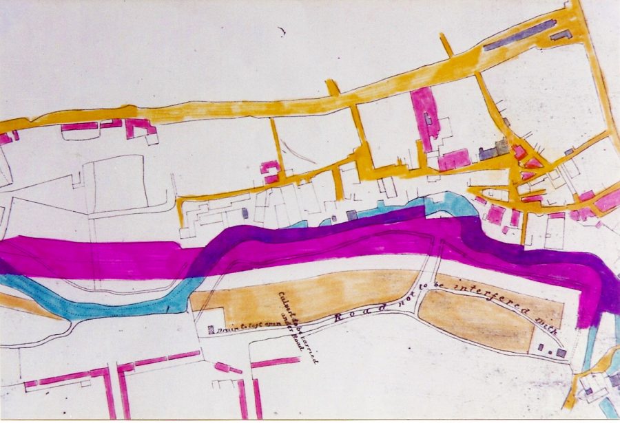
Between Standard Quay and the Creek head the navigation was also straightened. This mean that some bankside properties had to be demolished and that others, like the town warehouse (now the T.S. Hazard) ended up further from the waterside than they had been. In the plan seen here the old course of the Creek is coloured blue, the new violet.
It had never been easy for vessels to make way in the Creek under sail, and for this reason skippers had had to engage the service of ‘hufflers’ – men who would meet vessels at Holly Shore , take a line ashore, and tow them in to Faversham by hand, usually using the west bank. This primitive, but effective, procedure took the name ‘a couple of bob on the line’ because two shillings (10p) was the rate for the job. Mechanisation of the task came in 1844, with the purchase of a steam tug.