By the 18th century there was a bridge at the head of the Creek, by the north end of Stonebridge Pond, linking West Street via Flood Lane with Brent Hill. Though it may have been rebuilt in the 19th century, this still survives.
The Home Gunpowder Works, part of which lay alongside the Pond, had been nationalised by the Government in 1759, and new process-houses and stores had been built by its Board of Ordnance on the north side of Brent Hill. Presumably the bridge was built to link the mills and other buildings alongside the Pond with these factory extensions. However though it formed a useful foot-route the carriageway was narrow; and to this day beyond the end of Flood Lane remains unadopted and so not maintained by the highway authority.
It was not until 1798 that the first bridge, and sluice, on the site of the present one was installed. It was built by the Board of Ordnance, whose Home Gunpowder Works stretched from just N of Ospringe Street to the head of the Creek.
Thus two birds were killed with one stone. If the sluice gates were closed at high tide, vessels serving the Works could berth close to ground level in a newly-created basin; if there were no vessels in the basin, the sluice-gates could be opened to flush out silt from the lower reaches of the Creek.
The Works was at its busiest during the Napoleonic Wars, so the new arrangement could not have come too soon. The bridge was probably of wood, and it is not clear whether it was lifted, swung or slid out of the way when vessels needed to reach the basin. It was only a footbridge, but for pedestrians made access to and from Davington easier from the Abbey Street area. Perhaps because of this Faversham Borough Council contributed £400 to the cost – the equivalent of about £12,000 today.
Not surprisingly the bridge was known as the ‘Sluice Bridge’. It marked one of the official boundaries of the Port of Faversham, which then bordered the Ports of both London and Rochester and extended from Warden on the Isle of Sheppey and Elmley Island on the Swale as far as Reculver.
Till 1833 the Board of Ordnance was responsible for maintenance of both bridge and sluice, but in that year, after being paid £800 by the Board, the Borough Council became responsible. In 1843, as part of the major Creek improvement programme, the new Faversham Navigation Commission replaced the bridge with a substantial iron one, and also rebuilt the sluice.
It was still only a footbridge. In the Faversham News in 1926 John Mannooch remembered it as ‘telescopic’, moving backwards and forwards on rails, with railway wheels propelled by a windlass, presumably operated at the town end.
No photographs or sketches of it are known to have survived. By now much new development had taken place on The Brents and while the new bridge must have been a boon for pedestrians the lack of direct vehicular access must have been very inconvenient. Carts and wagons had to go the long way round, via either Flood Lane or Davington and Brent Hills.
This lack was remedied in 1878 when the present hydraulically-operated vehicular swing bridge was installed. The £1,500 cost was shared equally between the Navigation Commission, the Faversham Pavement Commission (a body later integrated with the Borough Council) and land-owners on the Preston (Brents) bank. The Navigation Commission kept the bridge in structural repair.
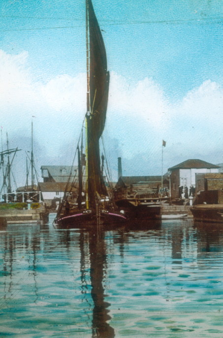
Illustrated this week is a sailing barge making for a berth in the basin through the open bridge in about 1895.
