Arthur Percival’s History of Faversham Creek
The History of Faversham Creek by Arthur Percival – Part 1
24 years isn’t a long time – or is it? In 1987 in its ‘Nutshell Guide’ series the Faversham Society published a booklet on Faversham Creek. This took the form of, first, a brief history (11 pages), and then a trail from the Creek head at Flood Lane and the foot of Brent Hill to Nagden (14 pages).
Already, in 2011, the trail is now hopelessly out-of-date. Most of the features it highlights between the Creek head and Standard Quay have either vanished or seen dramatic changes of use. They’re consigned to history. Most of them anyone who is new to the area will never have seen, be amazed that they ever existed. “You mean to say there used to be an animal feed mill, and before that a cement works, where I live?” and so on.
How come? Well, before that question’s answered, something about how the Creek comes to be here, and what part it has played in the area’s long history.
Take a look at the local 1”-scale sheets of the British Geological Survey, in particular those for the Faversham, Canterbury and Maidstone areas. They’re on sale at the Fleur de Lis Heritage Centre. Colourful affairs, they show very clearly (particularly the Canterbury one) slender green ‘fingers’ stretching rather like tree roots up the dip slope of the North Downs. ‘Dendritic’ is the term the experts use for this very distinctive pattern.
These green fingers mark where the underlying chalk comes close to the surface , and signify valleys. Every reader will probably be familiar with these – they are well-loved features of the local landscape, and outstandingly beautiful.
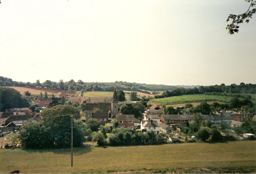
The Faversham Creek valley runs through Water Lane and Lorenden Park in Ospringe, and its tributaries to the top of the North Downs at Otterden, Stalisfield, and Throwley. Just to the west is the Oare Creek valley, better known as Syndale (‘wide valley’) or the Newnham Valley, as far as Doddington, and then also reaching the top of the North Downs at Frinsted and Otterden. Seen here is the village of Newnham, in the main valley, with a tributary valley coming down from Otterden.
The further south you go, the narrower the valleys mostly get, so the lanes which cross them are often very steep. From the tops of some of them they are striking distant views northwards. The countryside, thankfully, is all unspoiled.
How come, in turn, these valleys exist? They’re now dry, but surely they must have been formed by running water? Yes, indeed. In the Ice Age permafrost never extended south of the Thames Estuary, but it was still very cold, and snow capped the top of the North Downs for most of the time. When it melted it had to find its way to the sea, and in doing so it created these valleys.
But the underlying chalk is permeable and the water could simply have drained down into it? Yes, but the ground often remained frozen, and then the water could only drain off over it. The streams brought down with them flint and gravel deposits, and long after they had dried up, from the 20th century till today, these have been exploited for use in road metalling and construction work.
These streams dried up many millennia ago, but towards the north end of their courses springs provided residual water sources for the two Creeks, which were also swept by tidal waters. Though in each case springs may once have risen higher up their courses, Oare Creek came to be fed by springs along Bysing Wood Road and Faversham Creek by ones rising just beyond Lorenden Park. Because of ever-increasing demand on the aquifer, the latter (‘the source of the Nile’ jokingly)finally dried up about 40 years ago, and the only permanent springs left to feed Faversham Creek with fresh water rise in the stream bed outside Chart Gunpowder Mills and at the SW corner of Stonebridge Pond.
History of Faversham Creek by Arthur Percival – Part 2
We focussed in Part 1 on the geological origins of Faversham and Oare Creeks and the pattern of well-watered valleys which once fed them. Now a look at their early history, about which in truth not a lot is really known.
Geographers tend to describe creeks and inlets like these as ‘rias’, from a Galician word meaning valleys drowned by the sea. “The branching creeks near Faversham have been produced by marine drowning of an essentially ‘dry valley’ topography,” says the offcial account of The Geology of the Country around Faversham.
There are many parallels in southern England, among them Chichester Harbour, Poole Harbour, the creeks around Shalfleet in the Isle of Wight, and the estuaries of the rivers Exe, Dart, and Fal (think of maps or aerial photographs of places like Topsham, Dartmouth and Falmouth).
In other words the Creeks only became navigable after tidal salt water swept up them from the Thames Estuary. Otherwise they would have remained shallow mini-rivers. So far, so good. However when historic times are reached there is a complication, the implications of which still need to be worked out, and understood.
Archaeological and other research strongly suggests that when the Roman Emperor Claudius invaded, and annexed, Kent in AD 43 local sea levels were much lower than they are today – by as much as 15 feet. This would mean that neither Creek would have been navigable, except at very high tides by shallow-draught vessels.
And yet several local Roman villa (farmstead) sites are close either to the Creeks or nearby inlets; and it seems likely that they were located where they were to be near navigable waters, so that products could be ‘exported’ to London and elsewhere. It tends to be assumed, for example, that the villa excavated near Abbey Farm in 1964 was located where it was because it was close to Faversham Creek.
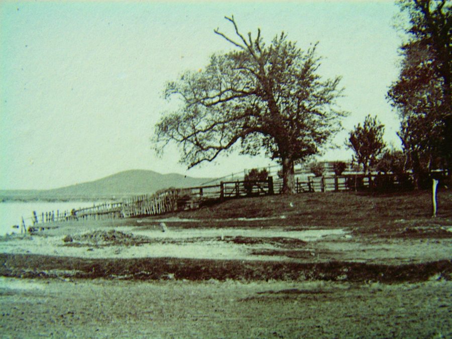
It has also been suggested that the artificial mound known as Nagden Bump (seen here in the background before it was levelled in 1953) was raised as a foundation for a Roman lighthouse. Here are puzzles to which knowledgeable readers may know the answers.
What is for sure is that in 699 somewhere in or close to Faversham was a place called Cilling (probably pronounced Chilling) and that, if not a home of royalty, it had close royal associations, since Wihtred, King of Kent, issued an important charter there in that year. More importantly – for Faversham Creek – it was later, in 814, described as a port.
On the basis of available documentary evidence, no scholar has yet managed to pinpoint it, but suggestions have been made that it lay by Ewell Fleet, about 600 yards north of Ewell, on the Graveney Road, or was simply a locality in Faversham itself – where at Kings Field there was a major burial ground whose name suggests that had royal associations.
By 811, when it’s first mentioned as ‘Fefres ham’, the town must have been well-established, because it’s described as such (‘oppidum’ in Latin). What’s more, it’s described in Latin as ‘regis’ (owned by the King), so the case for its identity with, or at least close affinity to, Cilling perhaps becomes stronger.
In its position alongside its Creek it must have been a port, and there are indications that, though a ‘limb’ (associate) of Dover, it was an original member of the Confederation of Cinque Ports when this was formed in the 10th century. By 1086 it also boasted a market – the oldest in the present county of Kent.
It’s clear in fact that Faversham would never have emerged as a town without its port. The Creek was its major asset, over-riding the disadvantage that the town’s site lay north of the Roman Watling Street (A2). The more so, too, because after Roman times the roads were in poor shape, as they remained for hundreds of years, and most freight and passenger transport was by water.
The history of Faversham Creek by Arthur Percival – Part 3
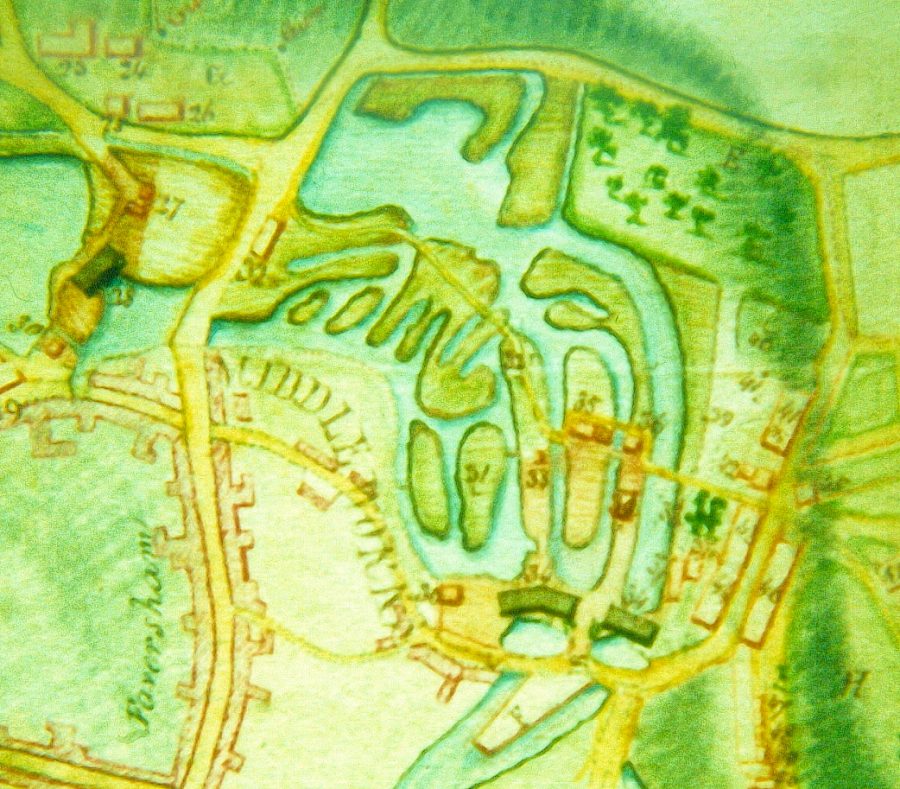
1822 plan of Stonebridge Pond
From Part 2 you’ll remember that there was a port (Cilling) somewhere in the Faversham area in 699; that Faversham itself was a town, and a Royal one at that, by 811; that it may have been a founder-member of the Confederation of Cinque Ports in the 10th century; and that without its port it would never have emerged as a town.
How far upstream was the Creek navigable in the early middle ages, soon after the Norman Conquest in 1066? This is the next question to which an answer is needed if we’re to understand how it influenced the town’s development. Unfortunately it’s a vexed one.
Nowadays there are two sluices to control water levels. One is under the Creek Bridge, the other at the head of the Creek. The purpose of the one under the Creek Bridge is twofold. First, at high tide it enables water to be retained in the Basin above it so that this can be released at low tide to clear silt from the Creek bed. Second, at high tide when the Bridge is swung open, it enables sea-going vessels to reach the Basin and berth there.
In fact this sluice has not been operated for many years and as a result mud and silt have built up in the main reaches of the Creek below it. Thanks to efforts by the Creek Consortium, the sluice gates have recently been repaired by the navigation owners, Medway Ports. This business is owned by Peel Holdings, whose HQ is in Manchester. Among its many other interests are the Manchester Ship Canal, the Trafford Centre in Manchester, the Ports of Liverpool and Sheerness, Liverpool John Lennon Airport and three other provincial airports.
The Creek Bridge, in case you ask, cannot be swung at present, because for some years it has needed major repairs. The Creek Consortium is trying to get these undertaken.
The second sluice, at the head of the Creek, cannot be seen, as it is at the north end of Stonebridge Pond, whose water level it is used to regulate. It is the present-day counterpart of the first sluice installed in 1558. The purpose of this, like the one under the Creek Bridge, was to build up a head of water at high tide so that the this could be be used to flush the Creek of silt. Illustrated is an 1822 plan of Stonebridge Pond, when it formed part of the Home Gunpowder Works. The road running ‘south-north’ on the left is West Street.
It took the place of a tide mill (Flood Mill) and the funds for it came from the bequest of Henry Hatch. Two years before his death in 1533 he’d said “I mean to bestow such cost upon the Haven and Creek that a ship with two tops [masts] may come up to the Crane [meaning probably Standard Quay]”. He was a successful merchant and businessman from Sundridge, near Westerham, and, as he had no children, had decided that as he’d made his fortune in the town he’d leave it most of the money and property he’d amassed.
His point was that in his day the Creek was so badly silted that big vessels could only get up as far as Thorn Quay, below the present sewage works. For the rest of their mile-long journey to or from the town, cargoes had to be moved, inconveniently, in carts or shallow-draught lighters.
The existence of a tide mill at the head of the Creek means that originally Stonebridge Pond and perhaps the lowest reaches of the Westbrook, which feeds it, were tidal and so perhaps, before it was built, navigable by small shallow-draught vessels. Contours suggest that, if it was, such vessels may have been able to reach the lower end of Tanners Street, near which the town’s first Guildhall was standing in the early 16th century. But this is speculation and more research is needed.
The history of Faversham Creek by Arthur Percival – Part 4
When he died in 1533, successful local businessman Henry Hatch left the town money for (among other things) the installation of a sluice to flush the Creek of silt. This was built at the north end of Stonebridge Pond in 1558, and its working enabled the big ships of the day to load and discharge cargoes in, or close to, the town centre rather than a mile away, at Thorn Quay.
Hatch would have been delighted with the outcome of his foresight and generosity. The town prospered as never before. Wrote William Lambarde in 1570: “This town flourisheth in wealth, for it hath not only the neighbourhood of one of the most fruitful parts of this shire (or rather, of the very garden of Kent) adjoining by land, but also a commodious Creek, that serveth to bring in and carry out by the water, whatsoever wanteth or aboundeth to the country about it.”
The fruits of Faversham’s late 16th century wealth we can still see today. Old houses were rebuilt, sometime on a grand scale – think of 1 Market Place (Purple Peach), 25 Court Street, 19 Abbey Street, and 81-83 Abbey Street (one house now split in two). As one journalist recently put it, the port had become the ‘larder of London’ at a time when the metropolis was rapidly expanding. For at least a century the city imported more wheat from Faversham than from any other port. Doubtless also its breweries had a big appetite for local hops.
While the harbours of some other members of the Cinque Ports Confederation silted up, Faversham remained open to traffic. England had always been renowned abroad for the fine quality of its wool, and by the 1680s the Creek was second only to Newcastle upon Tyne for the export of this product.
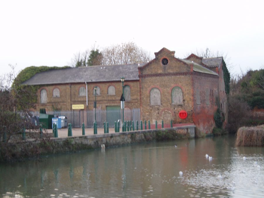
As a British Empire began to be built up there was an increasing demand for gunpowder. This was met by expansion of the Home Works, first of the town’s three factories. From its original nucleus around Chart Mills it spread upstream as far as the old Maison Dieu corn mill, and downstream as far as Stonebridge Pond. In 1705 the Borough Council transferred the working of the sluice at the Pond’s north end to the factory operator on condition that he widened it. In due course a dedicated Ordnance Wharf was built. Long disused for its original purpose, it now stands vacant, and its future is under discussion.
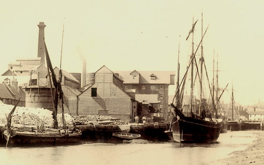
At the head of the Creek is the basin, seen in the photograph as it was in about 1890, when it was occupied by a shipwright and block- and mast-maker.
The Basin at the head of the Creek, circa 1890
Increasing powder cargoes were exported via the Creek, though not all legitimately. “Large quantities are being smuggled out of Faversham without coquet or security under pretence of His Majesty’s goods, but what it is or where it goes we are unable to give any account,” grumbled local Customs officers in 1673.
Smuggling in fact was a major local industry. The town was “notorious” for it, reported Britain’s first great investigative journalist, Daniel Defoe, in 1724. In the “arts of that wicked trade the people hereabouts are arrived at such a proficiency that they are grown monstrous rich,” he went on.
Fifty years later local surgeon and historian Edward Jacob attempted to redeem Faversham’s tarnished reputation. No-one who knew “the site and course of our Creek, which runs not less than three miles within land, would need to be convinced of the ridiculousness of the repeated assertion of this town’s being notorious for smuggling. … There is not one vessel belonging to it that is known to be employed in that iniquitous trade, or even suspected of it.”
This was carrying loyalty to his adopted town a bit too far. There are such things as blind eyes and deaf ears. Why else would no less than three coastguard stations later be set up along the local coastline?
The History of Faversham Creek by Arthur Percival – Part 5
How a sluice installed at the head of the Creek in 1558 transformed its fortunes we learnt in Part 4. Its operation cleared the waterway of mud and silt, enabling the big vessels of the day to load and discharge cargoes close to the town centre rather than at Thorn Creek, a mile away to the north.
In the words of William Lambarde, writing just 12 years later, “this town flourisheth in wealth, for it hath not only the neighbourhood of one of the most fruitful parts of this shire (or rather, of the very garden of Kent) adjoining by land, but also a commodious Creek, that serveth to bring in and carry out by the water, whatsoever wanteth or aboundeth to the country about it.”
And so, thanks largely to its Creek, the town continued to prosper for the next 250 years and more. Edward Hasted, the great Kent historian, gave the port a positive health-check. “Constant attention has always been paid to the preservation and improvement of the navigation of this creek, by the corporation, who take the whole expense of it on themselves.” The necessary funds they found by the imposition of ‘droits’ (tolls) on cargoes discharged at the various quays. Their right to do so was challenged in 1764, but upheld in court.
Hasted went on to describe the port’s trade. “The principal shipping trade is now carried on from this port by six hoys, which go alternately every week to London with corn, amounting in very plentiful years to 40,000 quarters of different sorts yearly.”
“Colliers likewise, of one hundred tons burthen, which supply not only the town but the neighbouring country with coals, and larger vessels, which import fir timber and iron from Polish Prussia, Norway, and Sweden, frequently resort hither, the principal proprietors and merchants concerned in them being inhabitants of this town. Besides which, there are several fishing vessels, and others, employed in carrying wool, fruits, and other traffic to London and other parts.”
There was also the oyster fishery. It supported over 100 families in the town. Faversham oysters were great favourites of the Dutch, who “have, time out of mind, kept up a constant traffic here for them, never dealing with any others, whilst they can purchase here those suitable for their consumption, at an equal price to those of the adjoining grounds, and generally laying out upwards of £3,000 [in today’s money £100,000] annually for them.”
However, “as these beds do not afford native oysters sufficient for the demands made for them, large quantities of small ones, called brood, are annually laid on these shores. These are collected from different parts of the sea, even from the Land’s End in Cornwall to Scotland and France, in order to increase and fatten, and be meliorated of their saltness, by the constant flow of the fresh waters from the Thames and the Medway.”
So far, except at Standard Quay, Town Quay and Ordnance Wharf, the flood-prone banks of the Creek lay mostly undeveloped. In 1812 the situation changed when Samuel Shepherd, of the brewing family, built a cement works at King’s Head Quay.
Seen here as it was about 115 years ago, this was one of the first of its kind in the UK. It took advantage of the ‘Roman cement’ developed by James Parker in the 1780s and patented in 1796. Part of Provender Walk now occupies the site.
This reproduced no original Roman product, but exploited the potential of the ‘septaria’ nodules found locally in the London Clay. Containing both clay and chalk, these could be burnt and then ground to a fine powder which, when mixed with sand, made an excellent mortar.
King’s Head Quay, where part of Provender Walk now stands, took its name from an old pub which was demolished in 1849 when the works was updated. Its name was transferred to a pub in Abbey Street, formerly known as The Mermaid and then The Smack. This is now No 14, and Smack Alley, alongside it, takes its name from the pub’s old dedication.
The history of Faversham Creek by Arthur Percival – Part 6
Faversham Creek prospered for over 250 years after a sluice to clear it of mud and silt was installed in 1558. However…
In the shape of the Whitstable & Canterbury Railway a challenge arrived in 1830. For at least 150 years, since Fordwich on the Stour had ceased to be accessible to trading vessels, Faversham had taken its place as the port for Canterbury and its hinterland. The new railway was connected to a brand-new harbour at Whitstable in 1832, and immediately the fortunes of the Creek and the town were in jeopardy.
The threat had been foreseen, it’s true. The Act authorising the Railway had been passed in 1825 and a year earlier the great engineer Thomas Telford had been commissioned to suggest improvements to the Creek. Its disadvantage was that its course from The Swale to the town was circuitous, making it difficult and slow to negotiate. This had not mattered when there was no competition, but now that there would be, it did.
To overcome this Telford suggested a new straight cut from Holly Shore, past Ham Farm, to Standard Quay – a short ship canal in fact. This was a suitably bold solution, but the necessary funds could not be raised from the business owners who might have benefitted from it. £32,000 (equivalent to £1.35m today) was needed, but not much more than half that put up.
So after Whitstable Harbour opened in 1832 trade began ebbing away. Improbably, but happily, the situation was transformed by the Municipal Reform Act three years later. Hitherto the town’s charities had been administered by the Borough Council but now an independent body was set up to manage them. Through the Hatch bequest, which had provided for the installation of the 1558 sluice, the new Municipal Charity Trustees had a stake in the Creek, and they instigated a new initiative for its improvement.
New plans were commissioned and the necessary Acts obtained to implement them. At £33,000 (equivalent to £1.45m today) they cost slightly more than Telford’s, but this time the money was raised. Under the auspices of a new Faversham Navigation Commission, work started on 1 August 1842 and was completed in the space of 13 months.
Two of the worst meanders nearest the town – Powder Monkey Bay and one at the north end of Front Brents – were eliminated by digging new channels across their loops; the whole channel from the head of the Creek to Nagden was widened and deepened; and a new sluice, with a bridge over it, was built on the site oif the present one.
The two meanders can still be seen. The bed of Powder Monkey Bay is now dry, but if you didn’t notice it an old boundary stone on one side of it would tell you that something here had changed.
This bears the initials F and P, telling you that the land lying within the old Creek loop is (or was) in the parish of Faversham, not Preston, as you might have expected if you knew that the whole of
The Brents was once in that parish. The other meander, by Crab Island, still floods when the tide comes in.
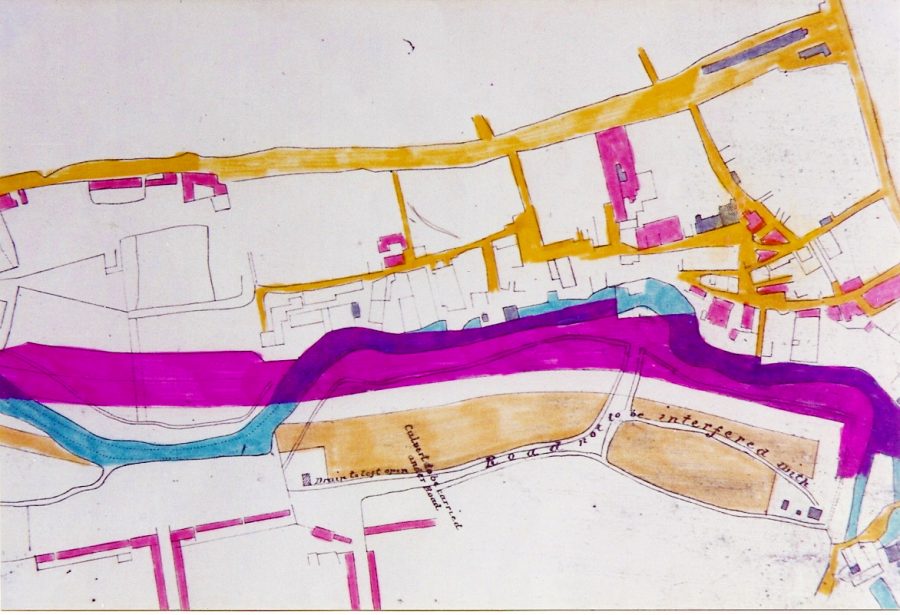
Between Standard Quay and the Creek head the navigation was also straightened. This mean that some bankside properties had to be demolished and that others, like the town warehouse (now the T.S. Hazard) ended up further from the waterside than they had been. In the plan seen here the old course of the Creek is coloured blue, the new violet.
It had never been easy for vessels to make way in the Creek under sail, and for this reason skippers had had to engage the service of ‘hufflers’ – men who would meet vessels at Holly Shore , take a line ashore, and tow them in to Faversham by hand, usually using the west bank. This primitive, but effective, procedure took the name ‘a couple of bob on the line’ because two shillings (10p) was the rate for the job. Mechanisation of the task came in 1844, with the purchase of a steam tug.
The History of Faversham Creek by Arthur Percival – Part 7
By the 18th century there was a bridge at the head of the Creek, by the north end of Stonebridge Pond, linking West Street via Flood Lane with Brent Hill. Though it may have been rebuilt in the 19th century, this still survives.
The Home Gunpowder Works, part of which lay alongside the Pond, had been nationalised by the Government in 1759, and new process-houses and stores had been built by its Board of Ordnance on the north side of Brent Hill. Presumably the bridge was built to link the mills and other buildings alongside the Pond with these factory extensions. However though it formed a useful foot-route the carriageway was narrow; and to this day beyond the end of Flood Lane remains unadopted and so not maintained by the highway authority.
It was not until 1798 that the first bridge, and sluice, on the site of the present one was installed. It was built by the Board of Ordnance, whose Home Gunpowder Works stretched from just N of Ospringe Street to the head of the Creek.
Thus two birds were killed with one stone. If the sluice gates were closed at high tide, vessels serving the Works could berth close to ground level in a newly-created basin; if there were no vessels in the basin, the sluice-gates could be opened to flush out silt from the lower reaches of the Creek.
The Works was at its busiest during the Napoleonic Wars, so the new arrangement could not have come too soon. The bridge was probably of wood, and it is not clear whether it was lifted, swung or slid out of the way when vessels needed to reach the basin. It was only a footbridge, but for pedestrians made access to and from Davington easier from the Abbey Street area. Perhaps because of this Faversham Borough Council contributed £400 to the cost – the equivalent of about £12,000 today.
Not surprisingly the bridge was known as the ‘Sluice Bridge’. It marked one of the official boundaries of the Port of Faversham, which then bordered the Ports of both London and Rochester and extended from Warden on the Isle of Sheppey and Elmley Island on the Swale as far as Reculver.
Till 1833 the Board of Ordnance was responsible for maintenance of both bridge and sluice, but in that year, after being paid £800 by the Board, the Borough Council became responsible. In 1843, as part of the major Creek improvement programme, the new Faversham Navigation Commission replaced the bridge with a substantial iron one, and also rebuilt the sluice.
It was still only a footbridge. In the Faversham News in 1926 John Mannooch remembered it as ‘telescopic’, moving backwards and forwards on rails, with railway wheels propelled by a windlass, presumably operated at the town end.
No photographs or sketches of it are known to have survived. By now much new development had taken place on The Brents and while the new bridge must have been a boon for pedestrians the lack of direct vehicular access must have been very inconvenient. Carts and wagons had to go the long way round, via either Flood Lane or Davington and Brent Hills.
This lack was remedied in 1878 when the present hydraulically-operated vehicular swing bridge was installed. The £1,500 cost was shared equally between the Navigation Commission, the Faversham Pavement Commission (a body later integrated with the Borough Council) and land-owners on the Preston (Brents) bank. The Navigation Commission kept the bridge in structural repair.
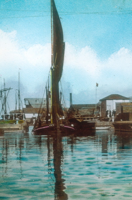
Illustrated this week is a sailing barge making for a berth in the basin through the open bridge in about 1895.
The History of Faversham Creek by Arthur Percival – Part 8
In Part 7, we recorded how in 1878 the £1,500 cost of the new (present) Creek bridge was shared equally between the Faversham Navigation Commission, the Faversham Pavement Commission (a body later integrated with the Borough Council) and land-owners on the Preston (Brents) bank. The Navigation Commission kept the bridge in structural repair.
In 1917, when the possibility of damage by enemy action loomed, and it was not entirely clear who was legally responsible for maintaining or, if need be, reinstating the bridge, the Navigation Commission, Borough Council and Faversham Rural District Council (then the highway authority for The Brents) clubbed together to seek Counsel’s Opinion on the matter, each agreeing to accept his Opinion, whatever it should be.
On 15 October 1917 Counsel, Gerald F Hohler KC MP, who had been fully briefed about the bridge’s complicated history, gave his Opinion that the Navigation Commission was responsible for maintaining the bridge, for reinstating it in the event of damage or destruction by enemy action, and for keeping the highway over it in good repair.
The bridge was swung open, when required, by a ‘bridge hand’. By the late 1980s traffic had dwindled to such an extent that this was very much a part-time job. The late George Gregory, of pedigree dredger stock, took the post after taking early retirement in 1974 and remained in office till 1987.
With his ancestry he was very attached to the Creek and was sad when he had to retire for a second time. “My duties include looking after the gates, maintaining the lifting mechanism and hydraulic pump house, swinging the bridge, recording arrivals and tonnages, notifying wharf owners of arrivals, and ensuring that the waterway is kept clear.”
The bridge was still swinging in 1993, when Bill Handley had taken over. However problems were beginning to develop. One of the abutments had been rebuilt in 1989 and a temporary coat of paint put on the underside of the bridge. Top coats were supposed to have been put on later, but they never were, and this led to metal corrosion which made operation difficult.
There were also problems with the basin. In the same year a report commissioned by KCC, Swale Borough Council and Faversham Town Council reported that 25,000 cubic metres of silt needed to be removed.
By 1996 the bridge had been out of action for two years and £43,000 was spent on repairs. The two sluice gates, each weighing 7 tons, were taken away for repair at Sheerness by the Medway Ports Authority, which had absorbed the independent Faversham Navigation Commission and is now a subsidiary of the Peel Group.
It seems that the Authority (now known simply as Medway Ports) may have overlooked its predecessor’s 1917 pledge to be responsible for maintenance of the bridge. Towards the £43,000 required it ‘donated’ £23,000, the remainder coming in contributions of £6,000 each from KCC, Swale Borough Council and the Hatch Charity, and £2,000 from the Town Council.
The Peel Group of which it now forms a part operates several big ports, as well as a number of regional airports. “Engaging with the communities in which we operate,” it says, “has always been central to our approach to sustainable growth.” One example of its “charitable and community engagement” has been a donation of £12.5 million to the Imperial War Museum North in Trafford Park, Manchester, to help it provide the area with a “world-class visitor attraction of great historical significance housed in an architectural masterpiece.” Perhaps a little of its largesse might one day extend in the Creek’s direction? Through Medway Ports it does own the navigation, after all.
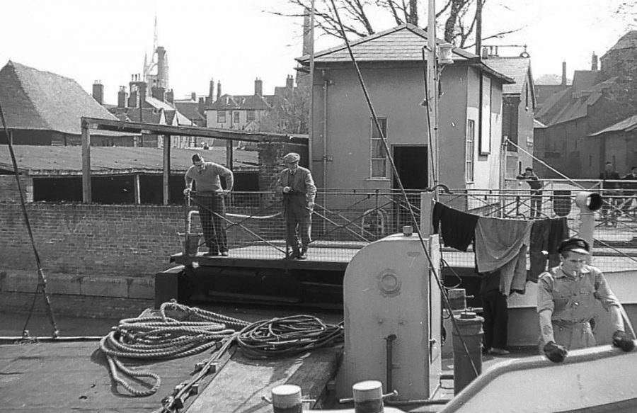
This week’s photograph, taken by a reader in April 1960, is of a motor barge easing through the Creek bridge to discharge cargo in the basin.
The History of Faversham Creek by Arthur Percival – Part 9
We have seen how the Creek’s viability as a commercial waterway was in jeopardy after the opening of Whitstable Harbour in 1832 and how it was successfully revived at the instigation of the Municipal Charity Trustees. They promoted a scheme to improve it by ridding it of its two worst meanders, re-aligning its town centre course, and widening and deepening the whole channel from Nagden to its head, by Stonebridge Pond. Rejuvenated, the Creek re-opened to shipping in September 1843.
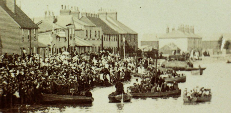
This investment soon earned a dividend. Port traffic steadily increased, to reach nearly 35,000 tons a year by 1868. On low-lying areas unsuitable for housing, new industry grew along its banks. In the basin a ship chandlery started on Ordnance Wharf, and a barge repair yard hard by, on the Brents bank. Fishermen could unload their catches close to North Lane, and sell them at the town end of the swing-bridge. Housing on the Brents rapidly expanded to the point that it needed its own places of worship, pubs and shops. It had its own strong sense of community, epitomised in 1908 when its people turned out in droves for a Creek regatta (pictured). John Matthew Goldfinch, the town’s leading shipbuilder, moved his yard and slipway to Standard Quay.
New employment opportunities meant increased demand for housing, and the town itself rapidly expanded to meet this. The legacy remains with us today in the shape of a rich and varied array of Victorian property. New amenities and community facilities were provided to match – the Rec, the Cottage Hospital, new schools and churches, for example.
Downsides? Yes, there were one or two. Raw sewage was still being discharged into the Creek, and the stench must have mingled malodorously with smoke from the stationary steam-engines which powered much of the new industry. It seems symptomatic that despite its historic aura and picturesque vistas Faversham was hardly ever visited by the artists who thronged towns like Rye and Sandwich. It must have been regarded as a dirty, smelly industrial place, not worth a first glance, let alone a second.
Throughout the later 19th century Creek trade continued to increase, and perhaps reached its apogee in 1895, when it handled inward trade of 446,481 tons and outward of 438,027.
In 1976, just 35 years ago, it was still a busy trading waterway. “A number of firms line its eastern bank,” reported the town’s Official Guide in 1976. “Dealing in such commodities as timber, fertiliser and animal feeds, they highlight Faversham’s function as a distribution centre for the surrounding agricultural area.” But then there was sudden, rapid decline. The last commercial cargo left in 1990, 14 years later.
Why this headlong collapse in trade? Why did the Creek emerge as a pioneer of the de-industrialisation which characterised Britain in the late 20th century? There seem to have been two main causes.
First, industry itself was in process of consolidation. To effect economies of scale, output was being concentrated on fewer, but bigger, centres of production and distribution. Second, a housing boom made industrial sites more valuable for their residential potential than for their existing uses. Governments encouraged such ‘brownfield’ redevelopments because they saved encroachments on Green Belts and farmland.
A third reason was perhaps that the Creek had lost its autonomy in 1968, when the Faversham Navigation Commission was dissolved, and its rights and duties were transferred to the Medway Ports Authority. The Authority was concentrating its attention, and resources, on the booming deep-water Port of Sheerness, and the Creek – a kind of ‘corner shop’ in relation to the shipping ‘supermarket’ of Sheerness – could not have come high in its priorities.
In the case of the Shipyard, which finally closed in 1973, there was a fourth reason. As in the case of counterparts elsewhere in Britain, it could no longer compete in international markets.
The History of Faversham Creek by Arthur Percival – Part 10
A look at the history of the Creekside.
In this series of features on the Creek let’s now start a stroll along its banks to see how its town reach has evolved over the ages. To plan properly for the future you have to understand the past, and nowhere is this more true.
The best place to begin is at Stonebridge Pond, one of Faversham’s great beauty spots, at the end of West Street. Remember that before it became part of the Home Gunpowder Works in the 17th century its waters would have been tidal and that small sea-going vessels may once have been able to reach the lower end of Tanners Street, where the town’s first Guildhall stood.
Turn back towards the town, across the Westbrook, which feeds the Pond, and then turn left down Flood Lane. This was once lined by houses on either side, and here at work a hundred years ago you could have seen a stave-maker. He soaked his wood in the waters of the Pond and then bent them into shape for the barrels coopers made for the brewing and gunpowder industries.
The Lane isn’t so called because it floods, but because it led to the town’s Flood Mill, owned in the 16th century by Thomas Arden, of Arden of Feversham fame. This in turn was so called because it was a tide mill. At flood tide salt water built up in the Pond behind it, then at low tide was released slowly to power its water-wheel.
In 1559, as you’ll remember from an earlier feature in this series, it was displaced by a sluice designed to flush the Creek clear of silt. There is still a sluice behind the brick wall which conceals the Pond at this point but its purpose now is only to control water levels. Alongside it there are remains of gunpowder mills.
On the left of the Lane, where houses once stood, is a pleasant expanse of greensward, with an attractive view over the Pond. It’s bounded by one of the narrow-gauge canals that were used by punts to move gunpowder from process to process. This was safer than moving it by carts whose iron-shod wheels might strike dangerous sparks off the flints in a track.
The Lane narrows towards its end. On the right is the Purifier Building, the only surviving relic of the town’s Gas Works, opened in 1830. It goes back to the 1870s or 1880s, and derelict for years, but now recently occupied by the Faversham Creek Trust, to be used as a Boatbuilding School – at last the first step towards rejuvenating the Basin.
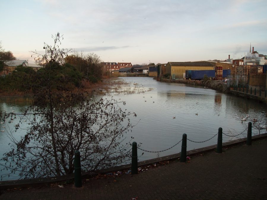
You could pop through into Morrison’s car park at this point to get your first glimpse of the Creek basin. There’s a short Creekside walk which it’s hoped one day – eventually! – may be extended as far as the Bridge.
Next on your right comes Ordnance Wharf, whose future is also uncertain. As its name implies, it was built by the Board of Ordnance when the Government nationalised the Home Works in 1759. Here deliveries of sulphur and saltpetre arrived, and cargoes of gunpowder left.
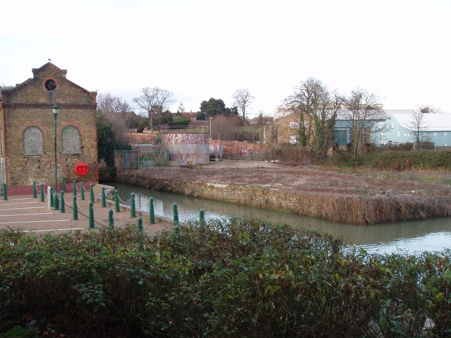
Towards the end of the 18th century the Borough Council became unhappy at such hazardous cargoes awaiting a tide so close to the town centre, so persuaded the Board to route them out via Oare Creek instead. A hundred years later a ship chandler had his premises here.
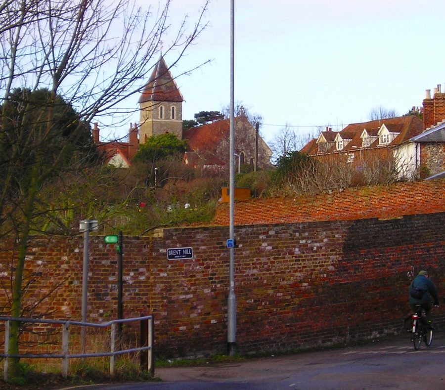
The far end of Flood Lane brings you into Brent Road, at the foot of Brent Hill. You’re now at the head of the Creek, and what a contrast! No more greensward, but a factory on one side of the road, and its car park on the other. Cast a glance back up Brent Hill (pictured). You realise, if you haven’t realised before, that Davington Priory is as close to the Creek as the Parish Church – so the building stone it needed when it was founded in 1153 could be delivered by water.
